Google Maps can now show Air Quality Index and Wildfire on Android and iOS apps

For hyperlocal details of air quality, Google will rely on PurpleAir, a low-cost sensor network which has broad coverage.

Avatar of Abhinav Kumar

By Abhinav Kumar

1 minute read

207 comments

Share article:

Follow us
Google Maps

Google Maps has added new features for the United States in its Android and iOS apps. The company will allow people to see the air quality of any place in the USA and keep people updated with active wildfires. 

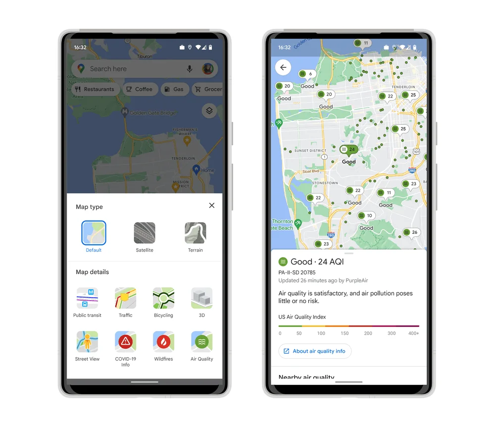
Both Air Quality Index (AQI) and Wildfires are added to the Google Maps app as layers similar to traffic, public transit, 3D, etc. “We collaborate closely with partners in the weather and air quality space to surface helpful and authoritative information when you need it most,” said Google in a blog post

The Air Quality data in Google Maps will be reliable and sourced from government agencies including the Environmental Protection Agency in the US. For hyperlocal details of air quality, Google will rely on PurpleAir, a low-cost sensor network which has broad coverage. 

AQI Google Maps
Source: Google

For Wildfire conditions, Google is partnering with the National Interagency Fire Center (NIFC). The Wildfire layer and its details will be available on Google Maps and can also be checked on Google Search by typing “wildfires near me”. 

“For larger wildfires, you can use Search to look up “wildfires near me”, and we’ll surface-associated air quality information along with useful information about the fire. In the coming months, we’re also adding smoke data across the U.S. from the National Oceanic and Atmospheric Administration (NOAA) to our air quality information on Google Search,” added Google. 

The map layers can be accessed by tapping the circular button on the right side below the search bar. The air quality layer will show coloured dots in various locations. Red is for very unhealthy, yellow and orange are for unhealthy, and green is for healthy air quality. 

Share article:

Follow us

Posted in:

AppsNews
Avatar of Abhinav Kumar

Abhinav Kumar

Editor

528 articles published
Abhinav is an editor at OnlyTech. He is a tech enthusiast who loves to read and write about new things. He spends most of his time tinkering with smartphones or computers when not writing about tech.

Related articles

Visit our forums

Join the discussions with thousands of active members who share the same interests as you and learn something new…

Forum replies (207)Comments (0)

Loading new replies...

Now when you hover your mouse on any location on Google Maps, you will see current temperature and weather conditions of that place. Google is providing the weather information layer in coordination with weather.com and the US Naval Research Lab. To activate the feature, you need to click on the widget on the upper right corner of the Google Maps.
The new feature also tells you if it is day or night in that place via sun and moon icons. Google hopes the weather information layer help in making travel and activity planning more convenient. Apart from the current temperature, you will now be provided with detailed data such as current humidity, wind conditions and even weather prediction for the next four days.

You can also change the units of wind speed (Mph/KMph/Mps) and temperature (F/C), and enable or disable the clouds.

Reply Like

click to expand...

Google’s added a new feature to its Street View maps – 360-degree views of the interiors of establishments. Google had started a test program for this in April last year, and now, the fruits are visible for all to see. For now, shops, eateries and other establishments in Australia, Japan, New Zealand, and the United States (as well as the cities of London and Paris) have been able to invite Street View photographers to capture their interiors.
Speaking about the new feature, a Google spokesperson said:
"We've been seeing renewed interest in the past few days because, as promised, we're getting more imagery online. The 360-degree views are really visually engaging, so we're glad users are excited."
The aim is to provide immersive imagery so that potential customers can imagine themselves at the establishment, to aid their decision of visiting it. The feature should provide businesses an interesting way to bring customers into the store before they are even in the vicinity of it. The program is entirely voluntary, and for now, is still in its trial stages, with only a few select cities in each of the announced territories actually getting the chance to call over a Street View photographer. Google intends to start expanding the program’s reach soon however.

View image at the forums

According to reports, Google is also directly offering establishments which are top-ranking on the site's searches the choice to add business photos to their Google Place page. The trial program is staying away from big brands, rather, will concentrate on smaller restaurants, hotels, shops and gyms.
Since the inception of Street View, concerns have been raised about the privacy of individuals in the images, whether at home, their workplace, or as bystanders. With the release of this latest feature, Google has announced it is blurring the faces of any bystanders to allay these very fears. The participation guidelines for Street View photography for businesses include the below information:
Business owners are told they must warn their customers and employees about the photoshoot before it begins. Google has promised it will blur out or refuse to publish any images that include bystanders.
The photoshoots will produce 360-degree images using fish-eye and wide-angle lenses as well as stills. Business owners are also invited to upload their own pictures.
Speaking about the project, a Google spokesperson told the BBC:
"Building on the Google Art Project, which took Street View technology inside 17 acclaimed museums, this project is another creative implementation of Street View technology, to help businesses as they build their online presence. We hope to enable businesses to highlight the qualities that make their locations stand out through professional, high-quality imagery."

Source : Digit

Reply Like

click to expand...

Leave a Comment