Google Maps Updates

Google Maps Adds Tons Of New And Updated Satellite And Flyover Imagery All Over The World


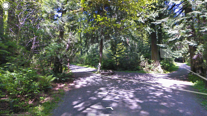
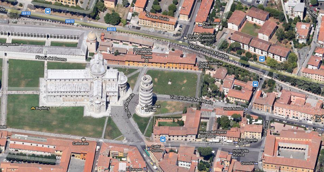
Google Maps is awesome. You know why it's awesome? Because of stuff like this. On the Lat Long Blog today, Google announced that it has implemented new 45-degree flyover imagery in 51 cities (such as below) around the world - 37 in the US, 14 abroad.

nexusae0_PIZZA_thumb.png


Satellite imagery has also been updated. 17 cities have refreshed space-based shots, along with 112 various regions in a whole bunch 'o countries. So, today's probably a prime opportunity to go around gloating to those friends of yours who are, shall we say, less geographically fortunate.
Here's the full list of locations with updated data.

Cities with new high resolution 45° imagery:

United States: Ames, IA; Anderson, IN; Billings, MT; Bloomington, IL; Carmel Valley, CA; Cedar Rapids, IA; Coeur d'Alene, ID; Corvallis, OR; Danville, IL; Dayton, OH; Detroit, MI; Dubuque, IA; Elizabethtown, KY; Enid, OK; Florence, SC; Grand Forks, ND; Great Falls, MT; Gulfport, MS; Hartford, CT; Kankakee, IL; Kenosha, WI; Lafayette, IN; Lancaster, CA; Lansing, MI; Lewiston, ID; Los Banos, CA; Madison, WI; Medford, OR; Michigan City, IN; Olympia, WA; Pocatello, ID; Sheboygan, WI; Sioux City, IA; Sioux Falls, SD; South Bend, IN; Terre Haute, IN; Utica, NY.

International: Angers, France; Clermont-Ferrand, France; Coimbra, Portugal; Dijon, France; Grenoble, France; Livorno, Italy; Lyon, France; Newcastle, United Kingdom; Oberhausen, Germany; Palermo, Italy; Pisa, Italy; Toulouse, France; Troyes, France; Winnipeg, Canada.

Areas with new high resolution aerial updates:

Florence OR, Kellogg ID, Casper WY, North Platte NE, Concordia KS, Alva OK, Austin TX, Nevada MO, Chilicothe MO, Toulouse FR, Clermont-Ferrand FR, Angers FR, Nantes FR, Troyes FR, Lille FR, Thun CH, Lucca IT

Areas new high resolution satellite updates:

Canada, United States, Mexico, Cuba, Jamaica, Haiti, Dominican Republic, Guatemala, Honduras, Nicaragua, Costa Rica, Panama, Colombia, Venezuela, Brazil, Peru, Bolivia, Paraguay, Uruguay, Argentina, Antarctica, South Africa, Namibia, Botswana, Mozambique, Zimbabwe, Madagascar, Zambia, Angola, Malawi, Tanzania, Democratic Republic of the Congo, Kenya, Somalia, Ethiopia, South Sudan, Sudan, Uganda, Central African Republic, Nigeria, Cameroon, Chad, Niger, Benin, Ghana, Burkina Faso, Ivory Coast, Guinea, Sierra Leone, Mali, The Gambia, Senegal, Mauritania, Western Sahara, Morocco, Algeria, Tunisia, Libya, Egypt, Israel, Saudi Arabia, Yemen, Oman, Qatar, United Arab Emirates, Kuwait, Turkey, Iran, Ireland, Norway, Sweden, Portugal, Spain, France, Italy, Poland, Lithuania, Finland, Belarus, Ukraine, Moldova, Romania, Hungary, Austria, Croatia, Serbia, Bulgaria, Greece, Russia, Kazakhstan, Uzebekistan, Turkmenistan, China, Pakistan, India, Sri Lanka, Bangladesh, Thailand, Nepal, Bhutan, Myanmar, Laos, Vietnam, Korea, Japan, Mongolia, The Philippines, Malaysia, Indonesia, Australia, New Zealand

Source
 
Now Google maps supports offline mode also. To get offline data you have to download the maps data for required region. For downloading the offline data, go to menu in the maps & select offline data section. It will ask to select a region for downloading data. It will also indicate the approx size of downloading data.

Well this was the options I was looking for, as online data is not available all the time specially when going outside city.
:tup
 
Oh that's great move by google. Really useful when no data network available.. Good share bro.. ;)
 
In what will most likely attract iPhone users disgruntled with Apple's map app, the tech giant plans to announce this week the addition of Street View to its Google Maps Web app.

p33.jpg


In the midst of Apple's iOS 6 map debacle, Google is looking to strengthen its grip on mobile maps.

According to AllThingsD, the Web giant is planning to announce the debut of Street View images to its mobile Google Maps Web app this week. The news comes from AllThingsD's Walt Mossberg's review on Google Maps for Android.

Here's more from Mossberg:

"Google plans to announce on Thursday that it is adding its popular Street View feature, missing from Apple's maps, to the Web version of Google Maps accessed from the iPhone and iPad. I tested this addition, which displays 360-degree photographic street views of selected locations, and interior photographic views of certain businesses, using sample links Google sent me. These links worked well, allowing me to see the locations and pan around with a finger."

When Apple opted to boot Google Maps from its recent iOS 6 -- essentially forcing customers to use its own native app -- many users got up in arms. Complaints about Apple Maps include inaccurate data, lack of details, distorted images, and erroneous directions.

Apple could have kept Google's more reliable and mature mobile mapping app, but it made a strategic decision about something it needed to own and monetize. Last week, Apple CEO Tim Cook addressed the growing furor over the beleaguered map app and said he was "extremely sorry" for the frustration felt by customers and vowed to improve the program.

In his apology, Cook pointed users to its competitors' apps, including Bing, MapQuest, Waze maps apps, or using Google or Nokia's map Web sites while the company works to improve its own app.

It seems that Google is now jumping in at just the right time -- upping its Web version of Google Maps -- to show that it will continue to strive to have the most user-friendly and reliable mapping system.

There isn't any news yet of Google releasing a maps app for iOS, however. And even if it does, it could still find ways to differentiate the Android version, such as including newer features or broader capabilities.


Google Maps to insert Street View into mobile Web app | Internet & Media - CNET News
 
Google Improves Maps With Its "Biggest Street View Update Ever", Updates 250,000 Miles Of Roads And Special Collections

Google Maps was already pretty great, with comprehensive Street View coverage in countries around the world, but it just got a little bit better thanks to the 'biggest Street View update ever', which is rolling out today.
Street View coverage has now been increased in no fewer than 11 countries, including the U.S., Britain, and Canada, with over 250,000 miles of roads being updated and added

nexusae0_ScreenShot20121011at12.02.10_thumb.png


The number of special collections, which allow you to see tourist attractions in countries all over the world on Street View, has also been doubled, with new locations added in South Africa, Japan, Spain, France, Brazil, Mexico, and more. These spots include parks, such as Stanley Park in Vancouver (above), as well as city centers, and other tourist attractions.
If you want to check out any of the new locations available on Street View, you see them on the Google Maps website, or go straight to the places that are mentioned in Google's blog post.

Google Improves Maps With Its "Biggest Street View Update Ever", Updates 250,000 Miles Of Roads And Special Collections
 
RailRadar.jpg


This is probably the coolest thing to have happened to the Indian railways. For those of us who’ve love our train travel, but want to keep a more accurate check on where exactly is their train travelling, Indian Railways has just launched RailRadar. You can check it out here: Indian Railways - Live! on Google Maps

RailRadar uses Google maps to track trains in real-time. The service is only available on 6,500 trains for now, but will be expanded in the future.

And how does one use this? On the screen right, your left, you will see, the option to search for trains. Click on it and type in the train number or name and it will show you exactly where the train is at the point. And if it’s not running it will reflect that. You can also find trains by entering the name of the station.

The blue light indicates that the train is on time, red means it’s delayed. We just started testing it, and found that currently there is a lot of red on the map! The maps also show the number of trains that are live on the chart, and the ratio of blue to red that is on time versus delayed trains, right on top.

You can also click on the train to see and a small pop-up will appear showing what time the train started, where it currently is and the status of the train.

You can also open the service on your mobile browser. Hopefully there will a live app for this soon!


Track your train via RailRadar powered by Google Maps | Firstpost
 
Back
Top Bottom
AdBlock Detected

We get it, advertisements are annoying!

Sure, ad-blocking software does a great job at blocking ads, but it also blocks useful features of our website. For the best site experience please disable your AdBlocker.

I've Disabled AdBlock